 |
| Part of Chhage Jharana |
Not
necessary to say, Dhulikhel is widely accepted touristic place that lies in
Kavre district and the beautiful city is about 30 kilometers to the east of
Kathmandu valley.
Today,
we are going to talk about a waterfall that was not known by many people till
now. Locals knew it as they used to block the stream to irrigate their farm and
as the saying has it: 'short pilgrimage
is the most neglected one', they didn't perceive it that one day it will be a
joyful destination for the youths of the district.
 |
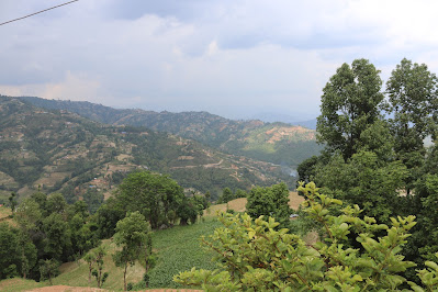
| Farmland of Rabi Village and distant Anekot village |
The
youngsters of Rabi village and Debitar village are quite enthusiastic to
develop it as an internal tourist hub. These two villages were separate village
development committee and now they have become first and second ward of
Dhulikhel municipality. These two villages contrast in many aspect: the ethnic
distribution of Debitar is dominated by Tamang community and Rabi by Brahmin
community with surnames Koirala, Chaulagain, Sapkota and Neupane.. The
education, social and political interest, health and sanitation, and human
development index is all very poor in Debitar. However, with new hope and
energy Dhulikhel municipality is planning to improve the situation. Now, a good
road has tourched Debitar.
 |
| Dhulikhel City as seen from Rabi village |
Furthermore,
Rabi village, though it is a relatively dry hill, shares its popularity for producing
vegetables, milk and livestock meat with Pachkhal valley. Rabi has widespread
organic production of tomatoes, cucumber, cauliflower, potatoes, green leaves,
cabbages, maize, onions, garlic and beans. This village harbors very old Seti
Devi Higher secondary school, and agricultural saving and credit co-operative
on the same name. There was Ginette Harrison charity boarding school which now
have merged with Seti Devi. The political awareness among the village dwellers
is noticeably high; and they mostly rely upon agriculture and jobs and
business.
 |
| Kuttal village and access road as seen from Chapleti |
Rabi
village is at about 5 kilometers of distance from Banepa major roundabout. The
road is black topped up to Chapleti, a wonderful hill that offers panoramic
view of Dhulikhel, Pachkhal, Anekot, Palanchok Bhagawati, Jugal and Gaurishankhar
Himalayan ranges. Banepa city dwellers find this hill as a morning and evening
walk destination as it takes around one and half hours walk round trip. From
Chapleti, the road is gravelled way down to Seti Devi school. The very road
joins to Samaj kalyan chowk of Pachkhal and is thus a proposed bypass road to
Araniko Highway from Banepa to Pachkhal.
 |
| Chapleti |
But
on the way, we don't go to the right of the road that leads to Tamaghat, we
just go straight down. The kutchi road is quite difficult, particularly in
rainy season. After two kilometers, there is relatively spacious dead-end of
the road where people can park their vehicles. From the place, we have to walk
around 15 minutes through ups and downs to reach to the waterfall area. There
are many waterfalls and the highest one is about 12 meters. Likewise, there are
many accumulated water ponds and the deepest one is about 8-10 meters.
 |
| The main Waterfall of Chhange |
The
waterfall is called Chhange jharana by the locals and is originated from the downward
slopes of Nagarkot hill which also forms Sashipani Jharana at Kashi Bhanjyang, a
scenic highland to Anekot. Since, the water is mixed with sand particles, it
seems turbid but is not a sewerage or filth-filled river unlike others.
 |
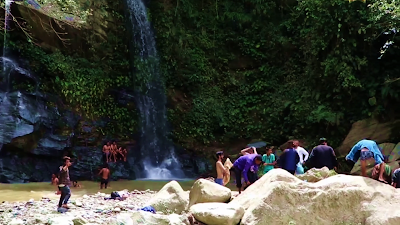
| Bathing in Chhange Jharana is a favorite pastime |
The
stream is called Chhahare Khola as the water is typically voluminous only in
the rains. This stream also severs as the bordering landmark for first and
second wards of Dhulikhel municipality. The waterfall, nowadays, witnesses,
hundreds of internal tourists from Banepa, Panauti, Khadpu, Sanga, Dhulikhel,
Pachkhal and neighboring villages and town daily. This place has now been
popularized by social media, namely Facebook and YouTube, particularly after
the local representatives started visiting and posting photos and posts in the
past month of lockdown.
"For
the easy accessibility a committee is being made that proposes stone-steps or
pebbling to join the motor track to the waterfall," says Mr. Harihar
Koirala, a local resident to Rabi village. Another youth activist Mr. Ishowore
Banjara is also enthused to participate in the development process of this area
that is seemingly thought to be led by municipal authorities quite soon.
Highlights
- Distance of Banepa from KTM: 26 km
- Distance of Chhange Jharana from Banepa Char Dobato: 8.5 km
- Time Taken: 30-35 minutes bike ride and 10-15 minutes walk (from Banepa)
- Activities you can do: Hiking, Sightseeing, Swimming in pond, bathing in the waterfall, basking in the sun on big rocks
- Eateries: There is no such commercial eateries, however, you have simple village style tea houses and basic grocery shops in Chapleti and Rabi gau.
- Transport: Motorbike goes upto parking spot except during heavy rain. Four wheelers only upto Rabi. You must hike 10-15 minutes.
For a detailed travel vlog to Chhange Jharana please visit:


0 Comments